- Nieuws
- Collectie
- Publicaties
- Jeugd
- Werkgroepen
- Platform
- KZGW
- Contact

- Nieuws
- Collectie
- Publicaties
- Jeugd
- Werkgroepen
- Platform
- KZGW
- Contact
uitgelicht
collectie-stuk
The WIC at the National Library of Brazil Collection
It was during the Dutch golden age in South America, as pointed out by Charles Boxer, that Brazil was finally exposed. This process probably started in the Orient with the Jan Huyghen van Linschoten’s Itinerario first published in 1596, which more than any other work was responsible for opening the young Dutch Republic to global trade and exploration through the creation of the Dutch East India Company (VOC), WIC’s elder sister. Linschoten was the first author to make a detailed painted voyage, drawing directly from nature the images of his Voyage to the East Indies and West Indies, which soon was translated into English in 1598[1]. He would go beyond his original scope in the Orient and, in the 1598 Intinerario English translation, added information about the Brazilian Northeast with a detailed description of the Brazilian coast, especially Pernambuco. A much-improved version of this plate will be part of Anoldus Montanus’s book, published in Amsterdam by Jacob Meurs in 1671.
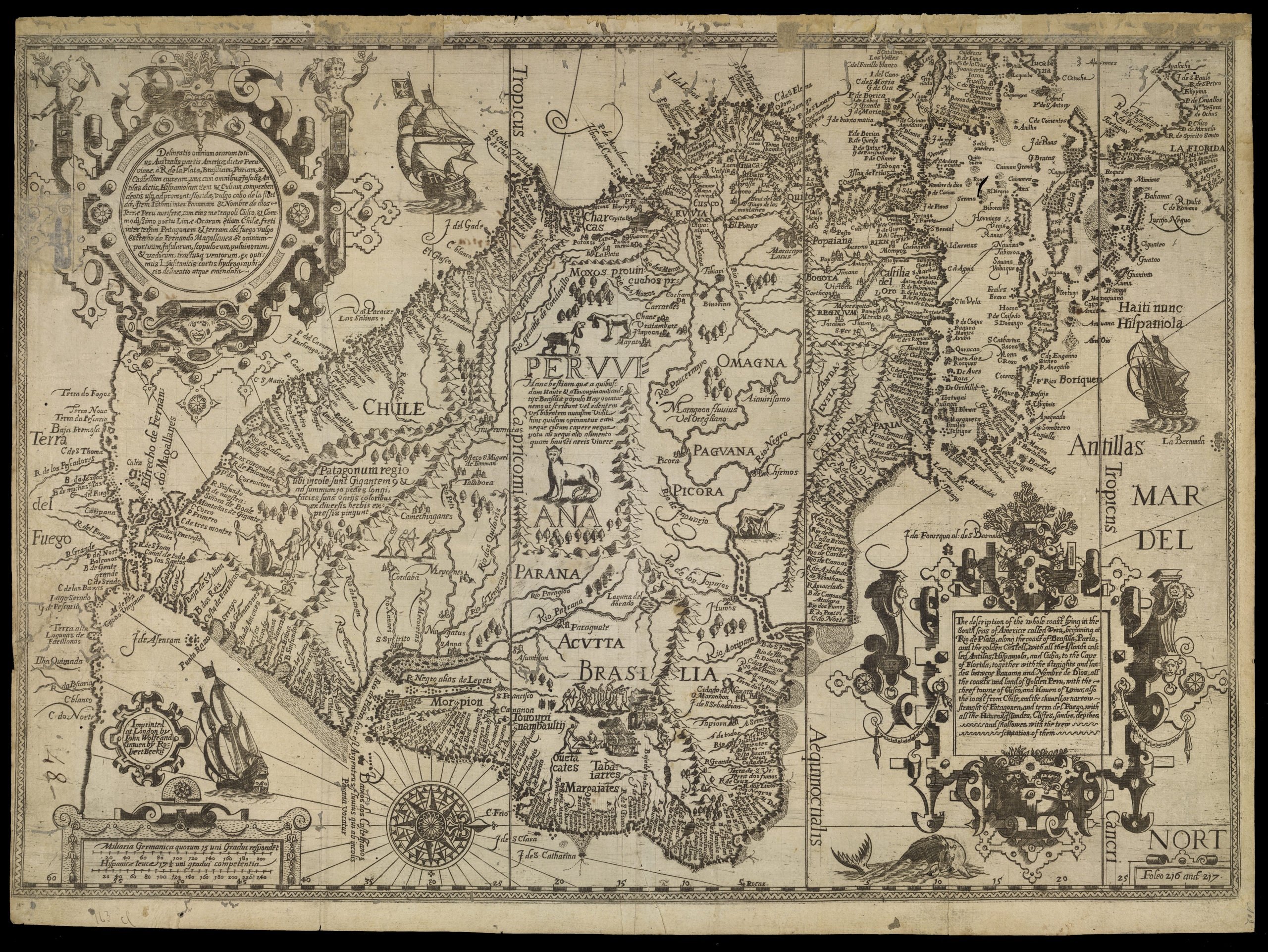
The Navigation and Itinerary of John Hugh of Linscot in Peru, 1598. Beckit, Robert after Linschoten, Jan Huygen van (1563-1611). Navigatio ac itinerarium Iohannis Hugonis Linscotani. The description of the whole coast lying in the South seas of Americae called Peru. Source: Linschoten, Itinerario, English edition displaying South America, Florida and part of Mexico. London: John Wolfe, 1598.
Jan Huyghen van Linschoten (1563-1611) had the opportunity to study the Eastern maritime route that could lead to profit and wealth. His descriptions and drawings of the Portuguese East Indies, especially of Goa, but also of China and East Africa, are an astonishing document still used as the only accurate early iconography of Portuguese India.
Although he was regarded as a spy, this Dutch clerk who sailed, via Cape of Good Hope to work as a bookkeeper for the archbishop of Goa, spent six years (1583-89) in India. His Itinerario led to the first Dutch expedition to the Orient. So lavish was the wealth displayed in the plates, and with such precision, that Linschoten’s book apparently served as a guide to Cornelius Houtman commanding the first Dutch expedition to the Orient that sailed on the 2nd April 1595[2], inaugurating on behalf of the United Provinces the route discovered by Vasco da Gama in 1498.
The artists and cartographers of Count Johan Maurits of Nassau-Siegen were to follow and enhance this tradition; they depicted extraordinary details about the land and the people of Brazil: a former world of fantasies that with the arrival of the Dutch artists was at last accurately documented.
The major innovation which the artists of the Johannes Maurits Mission carried out (…) was the attempt to reproduce for themselves an exotic reality without fantasies. They made Columbus’s words, in the letter dated 1493, acquire a meaning: ‘in these islands I have not yet seen a human monster, as many anticipated…’[3]
Although only the Northern-East Region was partly unveiled by 24 years of Dutch occupation of Portuguese America – most of Brazil remained formally concealed until the 19th century and beyond — it was the first occasion that the New World was properly described with maps and paintings. In spite of a long tradition of cartographers such as the Albernaz family, Luso-Brazilian art continued to have, in general, no interest in landscape, gender or nature, lacking representation through canvases, watercolours or engravings of landscapes and cityscapes, displaying scenes of rural or urban life that could satisfy the curiosity of foreign eyes.[4] The endeavour of Dutch artists and cartographers such as Georg Marcgraff (1610-1644) and Frans Post (1618-1680) was innovator: “Post’s Brazilian landscapes are unique in Dutch seventeenth-century landscape painting because of their exotic subject matter.”[5]
The scientific and artistic results of this seventeen-century Brazilian venture would lead the research of this period: “via a fascinating chapter of colonial history (with) early cartographers, Dutch artists of the Golden Age, neotropical ethnology and much else beside.”[6]
The works of Marcgraff, Post and Eckhout were used by Caspar van Baerle (latinized to Barlaeus; 1584-1648) the author of Rerum per octennium in Brasilia (1647), a full-length encomium of Maurits’ Brazil. For this account of Dutch Brazil, he interwove the narrative with images of the Country’s geography, history and natural life. Barlaeus, had at his disposal Maurits’s own archives and financial support, and enlisted the great minds of his day as collaborators. His work revealed in large scale through engravings, some executed by Jan van Brosterhuisen and Salomon Savery, Europe’s vision of the exotic lands of South America. Georg Marcgraf, along with the publishers Willem and Joan Blaeu, contributed to the maps.
“For an ephemeral moment, only twenty four years in almost five centuries since Pedro Alvarez Cabral arrived in Porto Seguro, the Dutch had a safe position in the Brazilian Northeast. From the capture of Olinda and Recife in 1630 until the signature of the Taborda capitulation in 1654, this corner of Brazil that is nearest to Europe was colonized by the Dutch West Indies Company (…). The colony will reach its climax during the seven years of the Count Johan Maurits”.[7]
An amazing total of 46 artists, craftsmen, scientists and scholars[8] of the Dutch period opened a window of illustration of the fauna, the flora and the people of the land that for 150 years will be the main source of scientific and cultural knowledge regarding Brazil. Boxer will consider them as “the standard works on Brazil” until the 19th century.[9]
The Dutch were the right people in the right place to do the first naturalistic and topographic registers of the New World, and they had Johan Maurits, with his extraordinary humanist vision, in command. This would produce an amazing seven-year Aufklärung in Brazil, since they had at the time the amazing Dutch school compromise with veracity. Such an extraordinary investment and concern by the Dutch West India Company could be justified as:
“Trade and colonies demanded detailed first-hand information on the newly acquired territories; so that once installed the West-India Company governors would encourage exploration. Scientific investigation was in this case combined with the capitalist enterprise of the Dutch West-India Company who needed accurate information on the nature of this new world.(…) Research into cartography, geography, astronomy, navigation, biology and medicine served to make the business operation more efficient.“[10]
Nassau was a visionary who took, perhaps too seriously, his motto Qua patet orbis, “as wide as the world’s bounds” and possibly went too far when he envisaged a fusion between VOC (Vereenigde Oost-Indische Compagnie) and WIC (West Indische Compagnie), thus uniting the East and West Indies[11]; it also shows his ambition of having the world entreasured to himself. The merging of VOC and WIC will actually happen in an unrealistic imagery such as the one seen in John Nieuhoff’s Voyages and Travels into Brazil and the East Indies (1669) and Piso and Marcgraff De Indiae Utrusque re naturali et medica (1658) frontpieces.
The importance of Barlaeus’ Rerum per octennium can be measured by the successive editions and translations during the second half of the 17th century. Five editions in toto that would climax in 1698 with an Italian version financed by the king of Portugal D. Pedro II (1648-1706): Istoria delle guerre del regno del Brasile; accadute tra la corona di Portugallo e la Republica di Olanda, by the Italian friar João José de Santa Teresa (1658-ca. 1733). Although Santa Teresa added the Portuguese royal arms with baroque putti, the etchings produced by the French engravers Benoit Forjat and Hubert Vincent and the Italian Giovanni Girolamo Frezza were mainly made after the work of the aforementioned Frans Post.
A less accurate representation of Brazil was the work produced by the above-mentioned Nieuhoff, a writer and amateur draughtsman, who acted as functionary of the WIC after the departure of Nassau. His 17th century narrative, translated into English in 1713, shows drawings, like representations of flora and fauna, that are unexpectedly close to the ancient and fabulous 16th century images, particularly when Nieuhoff, who worked both for the WIC and VOC, depicts East and West together.
It is possible to notice a source of cultural sub-product made after Albert Eckhout’s work of that time (1653-63) with his Brazilian motives; they will turn into figures employed out of context like transferred decals of exoticism. Since most of it was painted as samples out of context — made originally for scientific purposes collaborating with Historia Naturalis Brasilae[12]–, that iconography was employed as curiosities inserted in other scenarios. That was the case of illustrations made for the title page of Marcgraf’s Historia, or the one in Nieuhof’s Voyages, mingled with conspicuous elements of the East[13] – including “a poor and reversed copy of the famous Dürer (rhinoceros) woodcut of 1515”[14].
As shown in Barlaeus’ book, the Dutch period coincides with the first formal representations of Brazilian landscape with topographic rigour. Actually, Frans Post in Brazil tried to look at the landscape as it is, instead of seeing it in the archetypal ideal landscape of an Arcadian garden so much praised by Claude Lorrain (1600-82) or Nicolas Poussin (1594-1665). The Dutch artists in Brazil are a bridge from the age of exploration to the age of enlightenment:
“With their realistic approach to the world around them painters like Frans Post and Albert Eckhout are part of an important trend in Dutch seventeenth-century painting, namely the commitment to the most truthful and naturalistic record of nature possible“[15].
Count Johan Maurits brought draughtsmen to illustrate the New World, to examine, collect and draw the cosmos, anticipating by more than a century the scientific expeditions led by Joseph Banks, Alexandre Rodrigues Ferreira and Alexander von Humboldt in the second half of the 1700s. However, at the same time he was assembling a fantastic bulk of exotic cultural elements that he would dispose of during his lifetime.
Nassau was the pioneer of a tradition of travelling accompanied by professional artists to document new territories, a usage established much later by Bougainville and Cook in their voyages around the World. By doing so, he anticipated the Humboldian ambition of collecting the cosmos. Nevertheless, Nassau was a 17th century Prince, and his aspiration did not coincide with any idea of public interest, or public opinion, a criteria and concept that – as stated by Habermas – would only emerge in the 18th century[16].
Like the Portuguese before, the Dutch had great mobility in the Southern Seas. “The botanist and naturalist, (Georgious) E(verhardus). Rumphius (1628-1702), who later achieved great fame in the East Indies, enlisted for service as a young man in sunny Italy (…) but found himself on board of a ship bound for the still sunnier Brazil.”[17]
By prohibiting the direct commerce with other European nations, the Portuguese allowed the oriental traditions of Brazil to survive for nearly one hundred and fifty years since the ousting of the Dutch to the arrival of the Court from Lisbon in 1808. Such was the importance of the knowledge accumulated in Dutch-Brazil that Alexandre Rodrigues Ferreira, acting as an official of the Portuguese Crown, chose Marcgraff and Piso, the Historia Naturalis Brasiliae (1648), illustrated by Eckhout and Post, as a handbook during his 1783 expedition to Brazil[18].
“Part of the instructions Ferreira received from Domingos Vandelli (Ferreira’s former master in Coimbra) dealt extensively with how he should conduct himself on the voyage, supervise his assistants, and make detailed studies (…). In a letter of 31 October 1787 Ferreira was admonished by Minister Melo e Castro for not sending enough specimens.”[19].
[1] LINSCHOTEN, Jan Huyghen van, Itinerário: viagem ou navegaçao para as Indias Orientais ou Portuguesas, Lisbon, Comissão Nacional para as Comemorações dos Descobrimentos Portugueses, 1998.
[2] Portugal was already under Spanish rule, which would last from 1580 to 1640.
[3] HOETINK, Hans, R., (org), Zo wijd de wereld strekt. Tentoonstelling naar aanleiding van 300ste sterfdag van Johan Maurits van Nassau-Siegen, Hague, Mauritshuis, December 1979, p.203
[4]“Another aspect of that (Luso-Brazilian) painting, very draped and of primary colours, is the absence of local motives (…) in such way that the landscape is excluded of the impart informati (…)They (Luso-Brazilians) shut their eyes to the land and its people, the artists from Bahia, Rio de Janeiro, Pernambuco, had at that time the main characteristic of the ceilings a la Tiepolo or Andrea Pozzi whith which they complete the opulence of the naves dressed on gilded carvings.” See CALMON, Pedro, Historia do Brasil, Rio de Janeiro, vol. IV, sec. XVIII & XIX, Jose Olympio, 1961, p.1265. To ilustrate his work Calmon used anachronistic watercolours produced a hundred years later by Chamberlain, Debret et alli.
[5] HOETINK, Hans R., “Johan Maurits van Nassau, Founder of the Mauritshuis”, in Mauritshuis Ducth Painting of the Golden Age, catalogue, The Hague, Johan Maurits van Nassau Foundation, 1982, p.94.
[6]Whitehead, op. cit.,p.12.
[7] WHITEHEAD, P. J. P, and BOESEMAN, M, Um retrato do Brasil holandês do século XVII, animais, plantas e gente pelos artistas de Johan Maurits de Nassau, Rio de Janeiro, Livraria Kosmos Editora, 1989, p.11.
[8]See Boxer, C. R., The Dutch in Brazil, 1624-1654, Oxford, Clarendon Press, 1957(D.p.112). “We have seen that he fell in love with Brazil on the day that he landed in Recife, and he wrote of that country in nostalgic terms a twelvemonth before his death as “ce beau Pay de Brasil (sic), lequel n’a pas son pareil sous le ciel.”
[9]Idem, Boxer, p.113. Although Joseph Banks did scientific observation when in Rio in 1768, and the Philosophic Expedition of Alexandre Rodrigues Ferreira, took place before Neuwied et alli, both works remained unpublished until the 20th century.
[10] HOETINK, Hans R., “Johan Maurits van Nassau, Founder of the Mauritshuis”, in Mauritshuis Ducth Painting of the Golden Age, catalogue, The Hague, Johan Maurits van Nassau Foundation, 1982, p.16.
[11] BOXER, C. R., The Dutch in Brazil, 1624-1654, Oxford, Clarendon Press, 1957, p. 158.
[12] “The drawings and paintings produced in the Brazilian northeast under the government of Johan Maurits have their scientific importance taken from Historia naturalis Brasilae (Leiden, Franciscus Hack, and Amsterdam, Ludovicus Elzevier, 1648), Whitehead, p.27.
“This book represents the first complete natural history of South America”, FREEDBERG, David, “Ciência, Comércio e Arte”, in O Brasil e os Holandeses, 1630-1654, Rio de Janeiro, Sextante, 1999, p.202.
[13] In both cases they are fantasying Indians with turbans, and big African and Asian game. In the first case sharing the page with a dodo bird and a rhinoceros, and the second with an elephant, a flying squirrel, a lion and parasols.
[14]WHITEHEAD & BOESEMAN (1989) p. 29.
[15] HOETINK, Hans R., “Johan Maurits van Nassau, Founder of the Mauritshuis”, in Mauritshuis Ducth Painting of the Golden Age, catalogue, The Hague, Johan Maurits van Nassau Foundation, 1982, p. 74.
[16] HABERMAS, Jurgen, L’espace public, Paris, Payaot, 1978, pp. 39-40. The bourgeois order in the Brazilian context would be examined in Chapter 6.
[17] BOXER, C. R., The Dutch in Brazil, 1624-1654, Oxford, Clarendon Press, 1957, p.153.
[18]See SIMON, William, “Uma esquecida expedição científica à Amazônia no século XVIII”, in Viagem Philosophica, uma redescoberta da Amazônia, 1792-1992, Rio de Janeiro, Editora Index, 1992, p. 30.
[19] Idem p.30 and 43.
Image: The Navigation and Itinerary of John Hugh of Linscot in Peru, 1598. Beckit, Robert after Linschoten, Jan Huygen van (1563-1611). Navigatio ac itinerarium Iohannis Hugonis Linscotani. The description of the whole coast lying in the South seas of Americae called Peru. Source: Linschoten, Itinerario, English edition displaying South America, Florida and part of Mexico. London: John Wolfe, 1598.