- Nieuws
- Collectie
- Publicaties
- Werkgroepen
- Jeugd
- Wetenschapsplatform
- KZGW

- Nieuws
- Collectie
- Publicaties
- Werkgroepen
- Jeugd
- Wetenschapsplatform
- KZGW
Uit-
gelichte foto
Op dinsdag 27 juni 2023, van 14.30 uur tot 17.00 uur (en 9.30-12.00 uur Braziliaanse tijd) organiseert het Zeeuws Genootschap in samenwerking met de Biblioteca Nacional in Rio de Janeiro het symposium
‘The West India Company and Cartography ’.
Het symposium is onderdeel van een omvangrijker programma in 2021, 2022 en 2023. Het doel is de geschiedenis van de West-Indische Compagnie (WIC), die in 2021 400 jaar geleden is opgericht, in de volle breedte onder de publieke aandacht te brengen. Hiertoe zijn vier symposia georganiseerd en drie online exposities (in het najaar van 2023 live). De vier thema’s zijn: (1) De geschiedenis van de WIC, (2) De rol van Zeeland in de WIC, (3) Slavernij en (4) Cartografie.
De leden van het Zeeuws Genootschap zijn hiervoor van harte uitgenodigd.
Plaats van handeling: Biblioteca Nacional, Rio de Janeiro én online:
Programma Symposium ‘The West India Company and Cartography’ (>> .PDF)
27–6-2023, Biblioteca Nacional, Rio de Janeiro
09.30-12.00 Brazilian time
14.30 1700, Dutch time
The objective of this symposium is to study different aspects of cartography and its relevance for the West India Company (WIC). The cartography of the Atlantic started already in the end of the sixteenth before the WIC was established in 1621 as skippers and pilots were required to keep logbooks of their trips. Maps were either drawn by those who had seen the place or based on information gathered from witnesses.
Cartography was crucial for the West India Company and the East India Company in fact for all those involved in exploring other countries and continents. Coastlines were important as was the knowledge of enemy fortifications.
While Spaniards and Portuguese followed a policy of secrecy concerning maps, the Republic went for openness. In Leiden a course was set up in Dutch, and not in Latin as was usual for university courses, for cartographers, cosmographers, architects, surveyors and military engineers. The courses included mathematical sciences. and becoming a pilot of a ship. Maps were being corrected, improved all the time. Famous cartographers were Joan Blaeu and Joannes Vingbooms. For Brazil, Georg Markgraf has made extremely precise maps
===============================================
This symposium will take place, partially in the Biblioteca Nacional, partially online.
As speakers for this symposium these names have already been suggested:
* Maria Dulce de Faria, responsible for cartography in the Biblioteca Nacional
* Raymond Buve, emeritus professor from Leiden University, who has selected all the maps of the series Mauritiana, will speak about Chilean maps, amongst others.
* Oscar Hefting, New Holland Foundation, will deal with African cartography, in particular with the fact that Cape Town was a part of the East India Company.
* Gijs Bonck, senior Collection Management Officer, National Archive, Surinam cartography
* Júlio Bandeira, researcher, Biblioteca Nacional, comments on illustrations in maps
Each speaker has 20 minutes for her/his presentation, followed by 10 minutes for questions or comments
Chairperson: Marianne L. Wiesebron
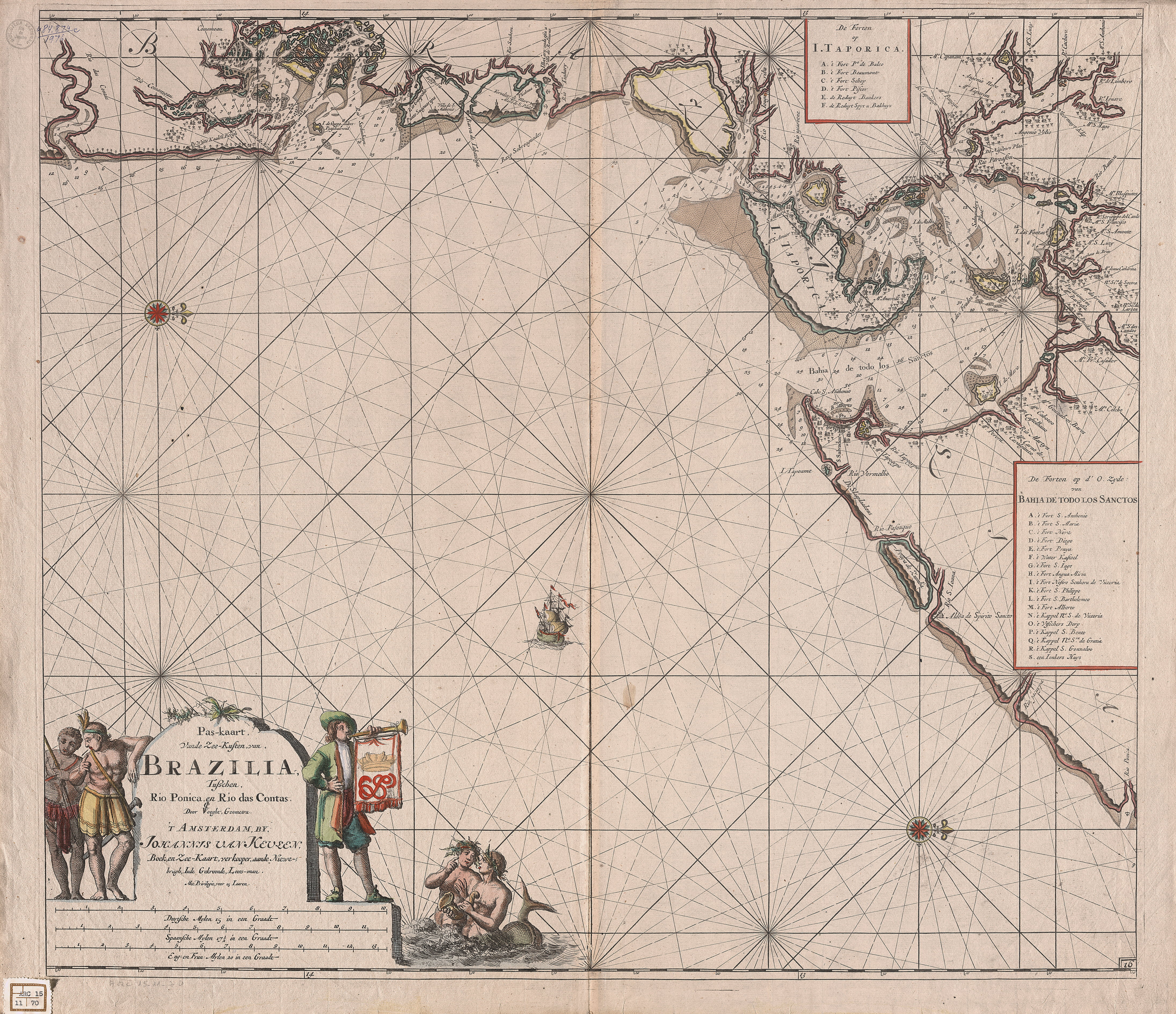
Afbeelding: Map of the coasts of Brazil between Rio Ponica and Rio das Contas, ca. 1696. Caption: Vooght, Claes Janszoon, m. 1696, Pas-Kaart van de zee-kusten van, Brazilia tusschen, Rio Ponica, en Rio das Contas Source: ‘T Amsterdam [Holanda]: Johannes van Keulen, boek en zee-kaart, verkooper, aande Niewe- brugh Inde Gekroonde, Loots-man…, [16–]. Biblioteca Nacional, Rio de Janeiro, ARC.015,11,070 OD: cart484874